WASHINGTON, March 29 —Oklahoma’s governor defended the state response to the seismic activity attributed to oil and gas development against a federal report on the hazard.
“Oklahoma remains committed to doing whatever is necessary to reduce seismicity in the state,” Gov. Mary Fallin said in a statement.
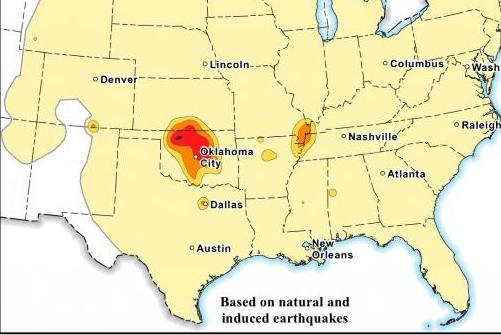
Her comments followed the release of the first-ever report from the U.S. Geological Survey on human-induced seismic activity in the country. A map produced by the USGS shows Oklahoma is the state with the highest risk of potential hazard from human-induced seismic activity.
Last year, the USGS found evidence to suggest seismic activity in the state may be tied to the disposal of wastewater from the oil and gas industry in underground wells. Two tremors were reported in Oklahoma in the past 24 hours, including a magnitude-4.2 event in Crescent, about 40 miles north of the state capital.
Fallin in January approved $1.38 million in one-time costs to support earthquake research in the state. State energy regulators, meanwhile, have called on energy companies to reduce the amount of wastewater disposed in underground wells in an effort to curb seismic activity. A plan for western Oklahoma went into force in February and expansions to a risk area in the central part of the state have been made.
The governor said the state was taking the right steps to curb seismic events, adding the USGS survey relied on data gathered before policies on wastewater were enacted in force.
“Recent declines in produced wastewater disposal in Oklahoma are not reflected in the USGS map,” Fallin said. “This gives us even a stronger base in going forward and gives state regulators further justification for what they are doing.”
Rep. Richard Morissette, a state Democrat, was quoted in the Tulsa (Okla.) World as saying the governor was “more than a year late” in her response to the increase in seismic activity in the state.
The USGS said it reviewed a wide range of literature to determine whether seismic activity was natural or induced. Mark Petersen, chief of the USGS mapping project, said researchers were careful to assess oil- and gas-related activities when making their determinations.
“Of course there is a level of uncertainty associated with this and all hazard maps,” he said in a statement.
[Source:- UPI]


