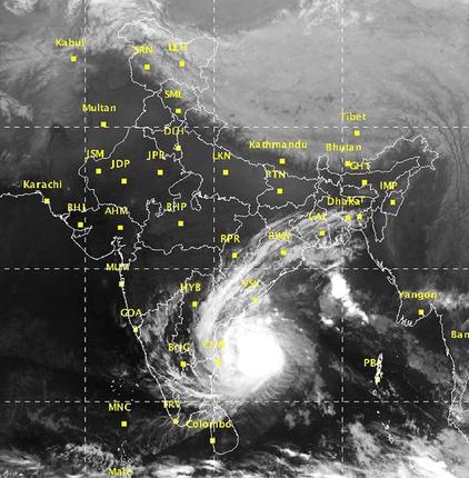
‘Vardah’ a very severe cyclone, has closed in on the north Tamil Nadu and adjoining south Andhra Pradesh coasts and is projected to make landfall at a place close to Chennai on Monday afternoon.
An India Met Department (IMD) warning said that a tidal wave of about one meter height above the astronomical tide could inundate the low lying areas of Chennai, Thiruvallur and Kanchipuram districts of Tamil Nadu and Nellore and Prakasam districts of Andhra Pradesh during the landfall.
Rough seas
Sea conditions will be ‘rough’ (wave height between 2.5 m and 4 m) to ‘very rough’ (4-6 m) along and off the Andhra Pradesh and north Tamil Nadu coasts from Monday night.
It will become ‘high’ (6 -9 m) to ‘phenomenal’ (14 m and above) from Monday morning.
Fishermen are advised not to venture into the sea along and off the south Andhra Pradesh, north Tamil Nadu and Puducherry coasts during the next two days.
On Sunday afternoon, ‘Vardah’ had reached within 440 km east of Chennai, signalling a clear shift in track to being more westerly than thought and a landfall at a more southerly a location.
Shift in track
The track is expected to shift further to the west-south-west into Sunday night, which can bring the gradually weakening storm even closer to Chennai for a landfall.
‘Vardah’ is expected to erupt over the coast as a conventional cyclone to the accompaniment of typically high winds and heavy to very heavy rainfall at isolated places.
The remnant of ‘Vardah’ is expected to travel west across the interior of the South Peninsula, bringing varying amounts of rainfall, before it heads into the Arabian Sea.
The rains should come in as a godsend for at least parts of the parched southern Peninsula, including those in interior Tamil Nadu, Andhra Pradesh and Karnataka.
Powerful cyclone
At its peak strength, ‘Vardah’ was ranked next only to the class-topping super cyclone on the five-step Saffir-Simpson scale of storm intensity.
The IMD has sounded an alert for rainfall at most places over Coastal Andhra Pradesh, North Coastal Tamil Nadu and Puducherry, with isolated heavy to very heavy rain from Sunday evening until Monday evening.
On Monday, the rains will scale up gradually becoming heavy to very heavy rainfall (7-19 cm) at a few places and isolated extremely heavy rainfall (more than 20 cm) over Chennai, Tiruvallur and Kanchipuram districts of Tamil Nadu and Nellore and Prakasam districts of Andhra Pradesh.
Squally winds with speeds reaching 40-50 km/hr, gusting to 60 km/hr, will prevail along and off the Andhra Pradesh and adjoining north Tamil Nadu coasts from the previous night.
Follow-up wave?
The wind speed will accelerate to 80-90 km/hr gusting to 100 km/hr during the time of landfall along and off the Chennai, Tiruvallur and Kanchipuram districts of Tamil Nadu, and Puducherry as well as the Nellore and Prakasam districts of Andhra Pradesh.
Meanwhile, global models have pointed to the possibility of ‘Vardah’ being followed by another wave of rainfall approaching the South Tamil Nadu coast and adjoining Sri Lanka.
This is likely to constitute an easterly wave, an elongated area of low-pressure not amounting to storm strength, but capable of creating prodigious rain under favourable conditions.
It is another matter that storms have been generated out of easterly waves in the past, which requires this wave to be monitored to ascertain the level of its ‘mischief-making ‘potential.
A US-based tracker is of the view that the storm would leave a trail of heavy to very rainfall over the South-West Bay of Bengal, reserving some of it for land (South Tamil Nadu and Sri Lanka) as well.
[Source:-Business Line]


